Information about General Page
Species
Common name - The common name of a species is from the AOU list of common names (http://checklist.aou.org/ click on "Checklist CSV Export")
Scientific name - Genus and species from the AOU list.
Drop-down box - The drop-down box allows selection of species on the Minnesota list. This list of species is updated by MOURC (Minnesota Ornithologists' Union Records Committee) when a new species is reported in Minnesota and accepted.
< and > - Buttons to move to the previous species and the next species.
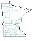
Occurrence Maps
Maps of Minnesota's 87 counties with the occurrence of a species in a county
for a season represented by a color or a dot.
The maps show the seasonal abundance of a species seen in each county.
The information
for these maps are derived from M.O.U. files, personal observations, and other sources.
The records used in these maps are gleaned from those published in The Loon
(seasonal reports, notes of interest, and articles), Minnesota biological survey data,
breeding bird survey, breading bird atlas, and lists submitted by individuals to the editor of The Loon.
Seasons are defined as:
- Spring: March, April, May
- Summer: June, July
- Fall: August, September, October, November
- Winter: December, January, February
Abundance terms are defined as:
- Common (C): Occurring as either widespread in distribution or locally in high numbers
- Uncommon (U): Occurs in small numbers. May be local in distribution or confined to specific habitats
- Occasional (O): Occurs sporadically often as individuals; local in distribution and usually confined to specific habitats
- Rare (#): Has only occurred in the county 5 or less records/season
These terms and criteria are not meant to be exact, but are designed to give an indication of the average abundance of species within an ecological zone. There is usually variation in abundance within an ecological zone.
Seasonal Occurrence in Minnesota
Graph - The graph represents all of the data in the MOU seasonal report database. The number of records for each day of the year is counted and then "smoothed" with a three-day filter. Since February has 29 days each 4 years, all years are treated as if they had 29 days in February, for the purpose of the graph.
Photograph
Photograph - The Photograph is from images submitted to the MOU web site. This image can come from "Recently Seen", "Showcase", "Galleries", or submitted with an "RQD".
Migration Dates
Extreme - These dates represent the most extreme dates observed in the most recent 25 years. These extreme dates are compiled on a year-by-year basis by Paul Budde.
Recent - Data for the most recent five years. There is a delay in posting this information because the records need to be reviewed and accepted by the seasonal report compilers, published in The Loon, and then compiled by Paul Budde.
Breeding Range in Minnesota
Minnesota Ornithologists’ Union Records - The records used to generate this map come from a variety of sources. The MOU has kept track of nesting species and has published this information in The Flicker and The Loon since 1929. This data is the result of observations from many volunteers. Many seasonal record compilers have worked on the MOU data during these years. Robert B. Janssen and Anthony X. Hertzel wrote a pamphlet called "Occasional Paper Number 2" that summarized nesting data of all species in the different counties of Minnesota. This has been a database for nesting records of birds in Minnesota. As additional records occurred, this database has been updated by the MOU Avian Information Committee. Starting in about 2003, MOU has been keeping all records of reported birds in a single database. These records are used to augment the data nesting data in the previous database.
Breeding Bird Atlas Records - The Breeding Bird Atlas project contributed a large number of records to the Avian database during the five years of the project from 2009 through 2013. Hundreds of volunteers and project partners contributed to the Minnesota Breeding Bird Atlas. Principle funding for this project was provided by the Minnesota Environment and Natural Resources Trust Fund as recommended by the Legislative-Citizen Commission on Minnesota Resources (LCCMR). Additional funding and in-kind donations were generously provided by Audubon Minnesota, Minnesota Department of Natural Resources, Minnesota Ornithologists’ Union, Natural Resources Research Institute of the University of Minnesota - Duluth, and the United States Fish and Wildlife Service.
In addition to data contributions submitted by MOU volunteers, data was also provided by: Audubon Minnesota, Cornell Lab of Ornithology, Golden-winged Warbler Working Group, Hawk Ridge Bird Observatory, Hormel Nature Center, Minnesota Department of Natural Resources, Minnesota Ornithologists’ Union, Midwest Peregrine Society, Minnesota Prairie Chicken Society, National Park Service, Natural Resources Research Institute of the University of Minnesota – Duluth, The Nature Conservancy, United States Fish and Wildlife Service, United States Forest Service, United States Geological Service, the University of Minnesota and the Wildlife Rehabilitation Clinic.
eBird Records - Cornell Lab of Ornithology has accumulated records since 2008. Since 2012 breeding records have been available to MOU from eBird.
Breeding Records -
Records accepted by the summer seasonal report compilers (Ann E. Kessen, Peder H. Svingen, and Paul Budde).
The position of the dots represent the reported location of the record.
For BBA records, the state has been divided into 9,774 quarter township size blocks. Each block has only one
type of record, either observation, probable breeding, or confirmed breeding. The highest type of breeding is selected
for each block, with confirmed breeding the highest priority.
If only the county is known,
a dot is added at an appropriate location inside the county. The dots are partially transparent
so if several dots occur in a similar location the dots are darker.
Historical Records - An open circle is displayed in the center of a county if there is a record of the bird breeding in a county, but no recent record of this confirmed breeding exists.
Confirmed Records - A transparent Green circle is displayed for each area that has confirmed breeding. If the precise location is known, the circle is displayed at that location. If only the county is known, the circle is displayed first in the center of the county and than at some other location in the county.
Probable Records - A smaller transparent Orange circle is displayed for each BBA area that has probable breeding (but not confirmed breeding.) If the precise location is known, the circle is displayed at that location. If only the county is known, the circle is displayed first in the center of the county and than at some other location in the county.
Summer Records - A smaller transparent Blue circle is displayed for each area that has a summer observation (but not confirmed or probable breeding.) If the precise location is known, the circle is displayed at that location. If only the county is known, the circle is displayed first in the center of the county and than at some other location in the county.
County Lines -
The coordinates for county lines came from
http://www.nohrsc.noaa.gov/data/vector/master/cnt_us.kmzThe coordinates for the state outline came from
http://www.nohrsc.noaa.gov/data/vector/master/st_us.kmz
Region Lines - The definition of the nine regions of Minnesota and the definition of the North/South line comes from Robert B. Janssen's book Birds in Minnesota. The lines used for this map came from Anthony X. Hertzel.
Rivers - Hand drawn by Anthony X. Hertzel.
Lakes - Hand drawn by Anthony X. Hertzel.
Cities - The position of cities was done with the help of Google. Text was added by David A. Cahlander and Anthony X. Hertzel.
Ecological Regions - Hand drawn by Anthony X. Hertzel based on a map generated by EPA ftp://ftp.epa.gov/wed/ecoregions/mn/mn_map.pdf
Important Bird Areas - Audubon http://netapp.audubon.org/IBA/IBA
National Forests - The MN-DNR’s Minnesota Geospatial Commons at https://gisdata.mn.gov/
State Forests - The MN-DNR’s Minnesota Geospatial Commons at https://gisdata.mn.gov/
SNA - The MN-DNR’s Minnesota Geospatial Commons at https://gisdata.mn.gov/
Wildlife Management Area - The MN-DNR’s Minnesota Geospatial Commons at https://gisdata.mn.gov/
Waterfowl Production Area - The MN-DNR’s Minnesota Geospatial Commons at https://gisdata.mn.gov/
Boundary Waters Canoe Area -
From Friends of BWCA
http://www.friends-bwca.org/visit/bwcaw/google-earth/
Records (Casual and Accidental species)
This is a complete list of all the sightings of Casual and Accidental species that have been reported and approved in Minnesota. Based on an earlier list compiled by Karl Bardon, Peder Svingen, and Anthony Hertzel, David A. Cahlander regenerated the entire list by examining all of the issues of The Flicker and The Loon. References to the published information for each record is included in this list. Source for this list is Notes of Interest, Seasonal Reports, and MOURC proceedings.
Christmas Bird Count
History - Beginning on Christmas Day 1900, ornithologist Frank M. Chapman, an early officer in the then-nascent Audubon Society, proposed a new holiday tradition—a "Christmas Bird Census" that would count birds during the holidays rather than hunt them.
Minnesota - For species that overwinter in Minnesota, this plot indicates how many individual birds are seen by each CBC participant. The data points are shown as dots and the line is a three-year average of the dots. Data collection is coordinated by the National Audubon Society. Note the MOU may not accept all data as submitted to Audubon as we have our own baseline criteria and thresholds of documentation for unusual records. Thus our displayed data can differ from what is accepted by Audubon.
Breeding Bird Survey
Source - North American Breeding Bird Survey at USGS, in particular, the department at Patuxent Wildlife Research Center in Laurel MD.
From https://www.pwrc.usgs.gov/BBS/PublicDataInterface
Minnesota - This represents the point count of birds seen in the Minnesota Breeding Bird Survey. The data points are shown as dots and the line is a three-year average of the dots.
Summer: The species has been documented to nest in 10 central, 9 east-central, 8 north-central, 7 south-central, 6 southeast, 3 northwest, 3 northeast, 3 west-central, and 2 southwest counties.


Spring
|


Summer
|


Fall
|

Winter
|
 Common Common |  Uncommon Uncommon |  Occasional Occasional |  Rare Rare |
Probable Records
Historical Records
Summer Records
County Lines
Region Lines
Rivers
Lakes
Cities
Important Bird Areas
National Forests
State Forests
SNA
Wildlife Management Area
Waterfowl Production Area
Boundary Waters Canoe Area
| 2022 | 2021 | 2020 | 2019 | 2018 | ||
|---|---|---|---|---|---|---|
| early south | 4/23 | 4/28 | 5/1 | 4/24 | 5/1 | |
| early north | 5/10 | 5/12 | 5/13 | 5/10 | 5/11 | |
| late south | ||||||
| late north | ||||||
| early north | ||||||
| early south | ||||||
| late north | 10/5 | 9/26 | 11/2 | 10/13 | 10/6 | |
| late south | 10/8 | 10/10 | 10/25 | 10/13 | 10/14 | |
| Data for the most recent five years | ||||||
| Median | 1st | 2nd | 3rd | |
|---|---|---|---|---|
| early south | 5/1 | 2005-04-20 | 2022-04-23 | 2016-04-24 |
| early north | 5/10 | 2009-04-24 | 2007-05-01 | 2001-05-03 |
| late south | ||||
| late north | ||||
| early north | ||||
| early south | ||||
| late north | 9/29 | 2016-01-02 | 2005-11-06 | 2020-11-02 |
| late south | 10/10 | 2020-10-25 | 2004-10-23 | 2003-10-20 |
| Information from 1998 through 2022 | ||||